Inspections for many diverse projects and types of industries. We help inspect for buildings, utilities, energy, civil infrastructure and real estate surveying.
As the infrastructure and power grid continues to age amidst a push to expand inter connectivity, the ability to monitor and inspect critical transmission, distribution and generation assets safely and cost effectively has never been more important.
Our aerial inspection service gives our clients the security of knowing the complete, real time condition of their valued infrastructure assets. The extremely high resolution images captured by our UAV’s (Unmanned Aerial Vehicles) combined with the vast industry knowledge of our inspection engineers ensures that the owner has the most comprehensive assessment information possible, allowing them to focus their energy on identified maintenance and repair issues.

Our UAV’s are remotely operated by highly skilled flight crews, assets can be inspected while remaining in service. This minimized downtime means direct savings for the owner.
FLIR Drone imaging inspections can detect heat loss defective solar panels pipeline insulation defects and leaks high voltage irregularities and vegetation health.
Searching for methods to locate heat loss, faulty solar panels, pipeline insulation issues and spills, high voltage inconsistencies and vegetation health? FLIR drone imaging examinations can assist!
Utilize the newest aerial imaging technology to swiftly detect issues from a secure distance. Uncover how FLIR drones can save time, money and better safety.
Introduction to Drone Imaging Inspections
Drones supply a cost-effective and proficient way to examine remote, hard-to-reach elevated places and expansive territories. FLIR thermal cameras can detect temperatures that are invisible to the human eye. They can also identify structural problems, like insulation issues and solar panel malfunctions. This helpful tool can even spot moisture infiltration or leaks in roofs and buildings, as well as detect vegetation health and boost security with perimeter surveillance in real-time.
The mixture of high definition digital images with thermal mapping makes it simpler to understand a building, asset or land’s condition. Drone operators capture multiple perspectives during an inspection which can be reviewed in different temperature zones on the spot to guarantee exact analysis of the inspected environment.
Detailed reports in PDF format with annotated pathways, known as heatmaps, point out where heat loss is probably happening. This allows for clear visualization of potential trouble spots. Catching any irregularities before they become bigger problems is wise when it comes to budgeting for future fixes. What’s more, drones eliminate dangers from ladders and scaffolding when inspecting elevations not possible from the ground, making it safer for all involved.


Benefits of Drone Imaging Inspections
Imaging inspections are very useful in many industries. By using drone technology and FLIR thermal cameras, businesses can spot and pinpoint issues throughout the year. Places that were hard to reach are now easily accessible! Drone imaging inspections make it simpler to recognize any areas of heat loss or overheating, so preventive action can be taken and expensive repairs can be avoided.
FLIR drones have amazing imaging capabilities. Drones with advanced cameras can spot defective solar panels, measure insulation losses, locate high voltage irregularities, and check vegetation health, with no need for personnel to enter risky areas or climb towers.
Imaging inspections also allow companies to find out where their energy dollars are flowing and where potential savings can be made. By combining visual imagery with temperature sensors, drones can produce detailed reports with temperature differences between components or across a facility. This enables decision makers to understand if energy is being used inefficiently, and if thermal insulation is performing well over time.
Drone imaging inspections are environmentally friendly too. They reduce air polluting emissions from traditional surveying methods, allowing organizations to save money while improving operations safely and looking after the environment.
Overall, drone imaging solutions help businesses make wise decisions about their assets. This lets them keep operations efficient and avoid costly damage before it’s too late.
Heat Loss Detection with Drone Imaging Inspections
Drone imaging inspections with thermal imaging are a cost and time-effective way to spot heat loss. FLIR Drone imaging inspections let people take accurate, contactless temperature readings from a distance, with just one person.
Inspection teams can use drone tech to scan for energy loss sources with an infrared camera. Hot spots on a roof may mean problems like bad insulation or roofing material that causes energy loss. Besides heat loss, drones can find leaks in ducts, solar inverters, solar panels and more.
FLIR’s advanced thermal drone solutions let energy auditors and facility managers assess roofs, buildings, pavement surfaces and objects from the air. This data reveals potential issues so teams can address them without wasting money on unnecessary repairs or replacements.
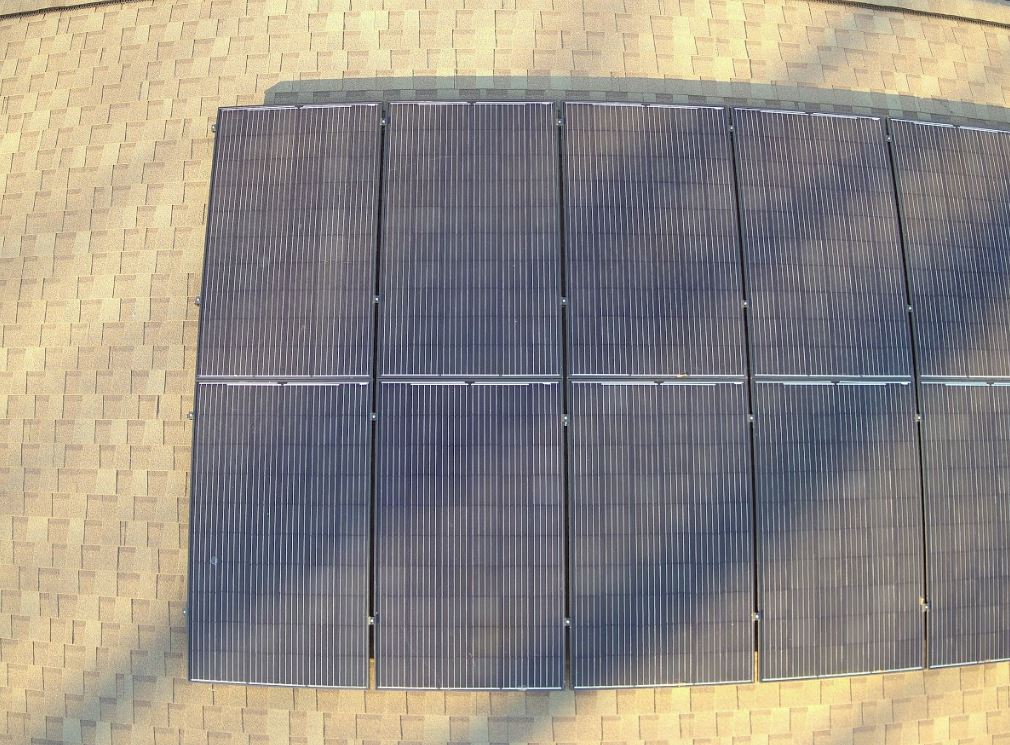
Defective Solar Panel Detection with Drone Imaging Inspections
Drone imaging inspections make detecting defects in commercial solar panel installations more effective and efficient. Surveying with drones is a safe and cost-effective way to inspect big solar facilities. Thermal imaging drones can spot solar cell defects which boost the efficiency of solar installations.
FLIR thermal drones offer a complete snapshot of how your solar panels are doing rapidly and accurately. Additionally, these results can be instantly analyzed with drone data analysis software such as FLIR’s SiteLink Software or DroneDeploy’s Autopilot feature for even more understanding into thermo-insulation defects and possible reduced output from specific panels or panels connected in series.
Solar facilities with decreased output lead to higher costs associated with energy generation and repairs/replacements. FLIR’s thermal drone inspections let users get the full picture with detailed, high-resolution thermal imagery of individual modules in large-scale projects to keep loss of power and energy efficiency at bay. Heat loss due to broken cells or incorrectly installed insulation can now be easily detected by trained visual inspectors using UAV thermal applications including models such as the DJI Inspire 2, Matrice 200/210 V2 and Mavic Pro equipped with FLIR Duo Pro R Thermal Cameras. The combination of precise thermography data and ease of use enables technicians to identify problems which stops catastrophic failure events that could cause multiple module failure events at once, allowing proactive maintenance instead of depending on reactive maintenance because of failure incidents.
Pipeline Insulation Defects and Leaks Detection with Drone Imaging Inspections
A FLIR thermal imaging drone inspection provides power to acquire thermal images in a safe, efficient way. This records exact temperature and heat loss for further analysis. Benefits include improved safety, greater efficiency, increased flexibility, cost-effectiveness, higher resolution data collection and accuracy.
Anomalies such as bubbles or wet spots can be identified from visual inspection results. These are back-checked by readings from an infrared camera. Data is also collected on surrounding environment conditions and temperature differences.
A report is generated with location of issues and recommendations on how to address them. Drone imaging reviews are quick and accurate ways of detecting potential issues within pipeline insulation. Left unnoticed, these can cause future damage or malfunctions.
High Voltage Irregularities Detection with Drone Imaging Inspections
FLIR Drone imaging inspections provide an effective and efficient way to detect high voltage irregularities. Utilizing infrared cameras, drones can safely scan large-scale industrial sites from a distance. This keeps the drones away from hazardous areas and potential electric shock or arc flashes. Drone imaging inspections can see issues at any time, regardless of weather or visibility.
Multispectral FLIR cameras on the drone can provide thermal imaging to pinpoint anomalies in high voltage systems. These images can show temperature differences like hot spots on electrical panels and lines, overloaded circuits, bad connections, faulty wiring, high resistance components, and undetected arcs or flashes.
Drone inspections help identify and resolve issues before they become hazardous. This improves safety and ROI.
Vegetation Health Detection with Drone Imaging Inspections
FLIR drone imaging is a speedy way to check vegetation health. A thermal camera can detect hot and cold spots. This indicates damaged or inadequate vegetation. It also helps to survey large areas and focus on leaf color and texture.
Thermal imaging is great for finding unhealthy plants. It shows if they have enough water and heat energy. Drones are cheaper than traditional methods. They help decide fertilizer, harvesting, crop rotation and pest control.
Analysis of drone images is efficient and accurate. It targets weak areas and confirms healthy ones. Long-term yield estimates and growth season plans become easier with this type of analysis.
Conclusion
FLIR drone imaging inspections are great! They’re non-invasive, fast, and accurate. Cost-effective too!
They can be used to spot problems, such as solar panel defects, pipeline insulation issues, high voltage trouble, and vegetation health. Plus, they can measure minor temperature changes – down to 0.1°C! This makes it easier to find structural integrity issues in hard-to-reach spots. Faster maintenance and repair time is the result!
Rob Haller, Drone Navigator
314-604-6544
saintlouisdrones@gmail.com
